As of 9/21/26
Please note this is unofficial and in no way connected with any Bear Brook officialdom.
Provided as a friendly pointer , use at your own risk!
CORRECTION:
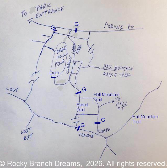
The Bear Brook trail map has a small but confusing error on the Hall Mountain/Ferret Trail where it goes past the cabin parking lot.
Not huge, but I found it a little confusing, not having hiked that section for a while.
The official map shows (leaving from Podunk Road) the Hall Mountain Trail going straight past its junction with the Hall Mountain Marsh Trail , with a short connector to the Ferret Trail coming later. That was accurate before the cabins opened.
Now the HM trail veers off into the parking lot after the junction with the HMM trail. Follow the edge of the parking lot the trail reaches an opening that leads to the Ferret Trail ( which is really an extension of the Cabin Road) , IN side the gate. Bear left ( away from the cabins) and pass the gate. That will take you to the junction with the Hall Mountain Trail , which is marked as non-maintained, but is in excellent condition.
UPDATE:
The HM trail past the park boundary is closed . It used to be practical to go past the house at the junction of Hall Mountain Rd and Wiggin Rd as part of a loop over the HM trail and/or the Ferret Trail. The gate at the Ferret Trail junction with the connector that goes to the HM trail has a closure sign (private property). I havent been out on the Hall Mountain side so I don't know whether that's actually signed, but I suspect it is.
There is also a pointer to a reroute. Traveling from the gate on the ferret trail headed toward the cabins, there is a junction with a new connector to the HM trail. The connector is very well cleared and a fine short walk to the HM Trail. This section of the HM trail used to be abandoned and was virtually impassable with mud and blowdowns. Today someone has shown it a lot of love and it is a very nice walk back to the cabin area. About midway there is another fresh cut connector that is signed as heading toward Hall Mountain. I assume it connects to the other leg of the HM trail, probably above the mudpits near the pond and the houses.
These connectors and the cleanup were a LOT of work, I'm sure. Hooray and thanks to those who did it !! ♥♥♥